News
- Tree & shrub handouts...Hall County: Friday, April 10th at Central Platte NRD Office (8:30-4:30) | Buffalo County: Monday, April 13th at NRCS Office (9:30-3:30) | Dawson County: Tuesday, April 14th at NRCS Office (10:30-3:00) | Merrick County: Wednesday, April 15th at NRCS Office (10:00-3:00) | Polk County: Wednesday, April 15th at NRCS Office (10:30-1:00)
- Upcoming Board Meeting: 2:00 p.m. Thursday, April 23
- Soil and Water Sample Requirements for Annual Report

CPNRD Board Takes Action on Flood Reduction Plans
February 27, 2026
Central Platte NRD Board Takes Action on Flood Reduction Plans
In 2020, the Central Platte Natural Resources District (CPNRD) was selected to receive three Watershed Protection and Flood Prevention Operations (WFPO) grants from the USDA Natural Resources Conservation Service (NRCS) to evaluate flood risks and identify potential solutions within the Elm–Turkey Creeks, Spring–Buffalo Creek, and Lower Wood River watersheds. The two-year grants covered 100% of costs associated with completing environmental assessments and developing watershed plans.
At its regular monthly meeting on Thursday, the CPNRD Board of Directors approved moving forward with the design phase of the Elm–Turkey Creeks Watershed Flood Risk Reduction Plan. Advancing to the design phase allows the District to pursue future funding opportunities but does not commit CPNRD to construction or additional project phases. Progress beyond design will depend on available funding, partnerships, and the timing of federal resources. Projects of this scale typically take several years to plan and complete.
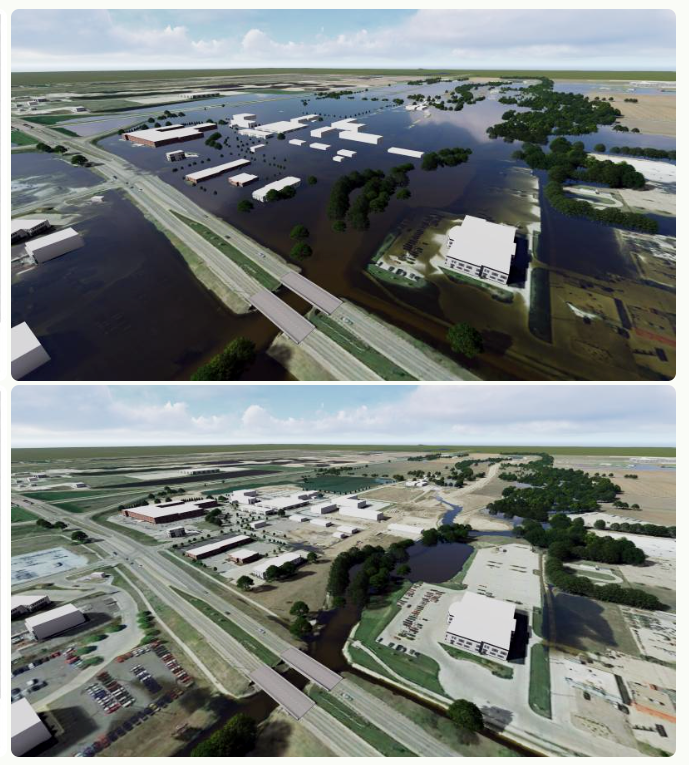
The Elm and Turkey Creeks watershed spans more than 106,000 acres in Dawson and Buffalo counties, including areas near the southern edge of the City of Kearney. Flooding risks within the watershed are influenced by the region’s flat topography and multiple flow constraints, including locations near I-80.
The approved design plan includes two diversion channels along the southern portion of the Turkey Creek watershed that would convey floodwaters south during a 100-year storm event, helping to prevent an estimated $90 million in flood damages in the Kearney area. The design phase will be fully funded by NRCS if federal funding becomes available. A project StoryMap is available at:
https://storymaps.arcgis.com/stories/5a104fadbc674bda9d8f85d9c1458582
Spring Creek Watershed: Also at Thursday’s meeting, the Board approved the Spring Creek Watershed Plan but voted not to proceed with the design phase due to a low benefit–cost ratio and a lack of public support. Approval of the plan allows partner agencies to revisit and use elements of the plan in the future.
The study area covers approximately 266,870 acres, consisting primarily of agricultural land, grassland/pasture, and row crops. The City of Lexington is located within the study area, while Cozad and Overton are adjacent to the watershed. In 2023, proposed revisions to the plan’s alternatives and economic analyses were reviewed with NRCS and the U.S. Army Corps of Engineers, resulting in the removal of Buffalo Creek from the alternative.
Lower Wood River Watershed: The Board voted to terminate the Wood River Watershed WFPO in 2024. The decision was based on the cost-benefit analysis, which showed that the level of flood risk reduction was not justified by the cost to address a 25-year flooding event. The plan, initiated in 2020, evaluated flood risk reduction alternatives for areas near Gibbon, Shelton, Wood River and Alda. The proposed design included a 400-foot-wide diversion channel west of the City of Gibbon.
-
Main Office
- 215 Kaufman Ave, Grand Island, NE 68803 308-385-6282
-
Cozad Office
- 75887 Road 414, Cozad, NE 69130 308-380-8943
-
NRCS Field Offices (Ext. 3)
- Central City 308-946-3035
- Kearney 308-237-3118
- Grand Island 308-395-8586
- Lexington 308-324-6314
- Osceola 402-747-2111
-
Quick Links
© 2026 Central Platte Natural Resources District