
Projects in Planning
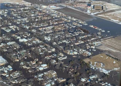
Much of the Central Platte NRD has long been plagued by floods. The Board has adopted the design and construction of flood control measures on a watershed basis and has developed over 30 flood control structures. The land area within the District is unusual in the fact that most of the tributaries of the Platte River run almost parallel to the Platte itself. Consequently, the tributaries span many miles of the flat terrace or bottomlands adjacent to the Platte before emptying into the river.
In the central and western ends of the District, most of the tributaries originate in the uplands where flood control structure sites are plentiful, but then drop off into the flat terrace or bottomlands and meander for many miles before reaching the Platte River. Many of the District’s other streams, such as Silver Creek, Warm Slough, and the North Branch, originate in the flat terraces or bottomlands where there are no sites for flood control structures. Even Prairie Creek has no flood control structure sites except in its extreme upper reaches. The Wood River has approximately 173 miles of channel meandering through the fertile Platte River Valley. There are numerous flood control structure sites in its upper reaches.
Projects Under Construction and Planning
WFPO - Flood Planning Grants
Dams Inventory
Platte Valley Industrial Park
Hazard Mitigation Plan
Ice Jams
WFPO Updates
Watershed & Flood Prevention Operations Program (WFPO)
In 2020, Central Platte NRD was selected to receive WFPO grants from the USDA Natural Resources Conservation Service to identify what is needed to address flooding within the Spring/Buffalo Creek Watershed, Lower Wood River Watershed, and the Elm/Turkey Creeks Watershed. The two-year grants pay 100% of costs to complete an Environmental Assessment (EA) and to design specific watershed plans. Virtual public meetings have been hosted to receive the public's input on issues in the three watersheds.
Elm Creek/Turkey Creek Watershed WFPO ($742,000) StoryMap
The CPNRD Board of Directors approved the Elm–Turkey Creeks Watershed Flood Risk Reduction Plan in January 2026 and will consider moving forward with the Design Phase on Thursday, February 26, 2026.
The study examined current flood conditions, evaluated options to reduce flood risk, and developed a plan to help lessen future flood impacts. Adoption of the plan allows the CPNRD to seek future funding for flood reduction efforts but does not commit the District to construction or additional project phases. Future steps will depend on available funding and partnerships, and the availability of federal funds will determine how quickly the design phase could move forward. Projects of this size typically take several years to plan and complete.
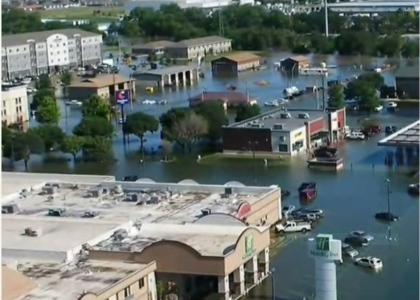
The Elm and Turkey Creeks watershed covers more than 106,000 acres in Dawson and Buffalo counties, including areas near the southern edge of the City of Kearney. The watershed is subject to multiple flooding risks due to the region’s flat topography and several flow constraints, including locations along Interstate 80. Planning began in October 2020 following a historic rainfall event on July 8, 2019, when over 10 inches of rain fell in the Turkey Creek watershed, causing extensive damage in the City of Kearney—particularly in areas north of Interstate 80 and west of 2nd Avenue. The flooding impacted local communities, residents, and property owners.
PROJECT PLAN: TWO DIVERSION CHANNELS
The alternatives analysis indicated that constructing two diversion channels would be the most effective flood mitigation option and would likely meet other Watershed and Flood Prevention Operations (WFPO) project requirements, including the required benefit-cost ratio. The combined diversion channels along the southern portion of the Turkey Creek watershed are designed to convey floodwaters south during a 100-year storm event and help prevent an estimated $90 million in flood damages in the Kearney region.
PROJECT COSTS
The planning phase of the project is 100% funded by the Natural Resources Conservation Service (NRCS). If the Board decides to move forward with the design phase, that would also be funded 100% by the NRCS when funds become available. The total project cost is estimated at $52 million, with a federal share of $27.26 million and a local share of $24.8 million. A
A feasibility study for $125,000 was submitted to the Nebraska Resources Development Fund to request cost-share for the projected $35M project. In 2006, a community meeting was held on the Elm Creek Watershed Flood Control Study and 130 landowners attended. The plan included a 975-acre flood control and re-regulating reservoir to be located northwest of Elm Creek, and 2 dry flood control structures on Turkey Creek. The reservoir would’ve provided flood reduction and recreation benefits. Cost estimate was $22.8M. Olsson Associates did a geotechnical investigation/seepage analysis by drilling 30 test borings at the reservoir site and adjacent lands to determine if leaching would raise water tables to a level that would create problems for cropland or basements.
Timeline
2012: The project was reviewed with a potential new Nebraska Water Cash Fund source. Partners: Olsson, NPPD, State of Nebraska, and PRRIP on options to move forward with a project estimated at 6,800-12,000 AF.
2013: $631,465 originally designated for Elm Creek Re-Regulating Reservoir was transferred to CNPPID’s new J-2 Reregulating Reservoir; cutting the Elm Creek project from the budget. J-2 was eliminated as a project.
2023: Amended water service agreement approved for $1.2M with NeDNR and Tri-Basin NRD to allow NeDNR to pay CNPPID $19,100,000 in advance to divert water into E-65 Canal, Phelps Canal, Elwood Reservoir and various waterfowl production areas to provide aquifer recharge for 15 years. CPNRD reallocated the funds to the project.
2025: Open House Elm/Turkey Creek WFPO Project
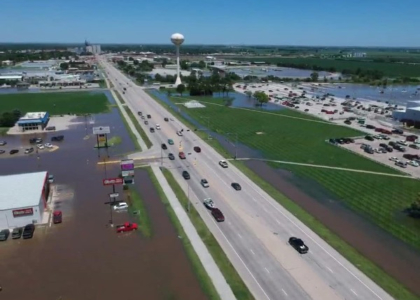
The NRCS, JEO, and Central Platte NRD will host a public open house the summer of 2025 in Kearney. The open house is part of the 30% design phase of the Elm/Turkey Creek Watershed Protection and Flood Prevention Operations (WFPO) Program to keep the public informed on project progress. The planning area includes more than 106,000 acres of drainage, covering the entire Elm Creek Watershed, from its headwaters to the confluence with Buffalo Creek south of the Village of Elm Creek, and the full Turkey Creek Watershed which flows north of Elm Creek, past Odessa, and through the City of Kearney. As part of the design, two diversion channels will convey floodwater to the south and help prevent flood damages in the Kearney region. The west diversion channel is currently estimated at 50 feet in bottom width and 5,200 feet in length.
Spring and Buffalo Creek Watershed WFPO ($750,000) Spring Creek Watershed Plan-EA
The Central Platte NRD Board of Directors will consider approving the Spring Creek Watershed Plan at their regularly scheduled Board Meeting on Thursday, February 26, 2026.
HDR Engineering developed the EA for Dawson County. The Plan area is approximately 266,870 acres, primarily ag, grass/pasture and row crops. Lexington is located within the study area, Cozad and Overton are adjacent. A possible split plan may be needed to accommodate the Village of Overton. In 2023, a plan to revise alternative and economic analyses was reviewed with NRCS and USACE, with Spring Creek 19-B as part of the alternative moving forward.
- Amendment to NRCS contract for a no-cost extension of time – April 2024
- Reviewing chapters 1, 2, and 3 of the plan. Revise alternative and economic analyses
- Coordinate with NRCS and USACE on alternative screening and preferred alternative
- Analyze Spring Creek 19-B as part of the alternative moving forward
- Finalize preferred alternatives for each site
- Prepare and submit Preliminary Draft Plan-EA to CPNRD and NRCS for review
A public meeting was held on Thursday, November 13, 2025, to present the draft Spring Creek Watershed Plan-EA and allow for public comment and comments were accepted through December 5, 2025. Meeting Materials
Wood River Watershed WFPO ($1,091,734) - Terminated Storymap
JEO and EA Consultants developed an EA for portions of Buffalo, Hall and Merrick counties. A virtual public meeting and milestone meetings were held in 2020.
- NRCS Notice of Intent (NOI) to prepare EIS was submitted to the Federal Register for Custer, Dawson, Buffalo, Hall and Merrick counties
- Held Public Information Meetings in March in Gibbon. Continuing work on Geotech/cultural review
- Working on diversion alignment options, analysis, and economic updates
- Notice of grant and agreement award received with additional funds - $366,734
2022: Alternatives, evaluation of potential projects and stakeholder updates were completed.
2023: Alternatives were reviewed included wetland delineations, geotechnical investigations and archaeological surveys to further analyze potential alternatives and locations. Potential projects included diversion channels,
channel and ditch widening, levees or berms and roadway modifications. Following completion of the EA, it was determined that more planning efforts were necessary. The project was upgraded to an EIS process in February to ensure a thorough understanding of flooding impacts and potential solutions. JEO’s contract was approved for $529,205.42 to develop the EA and to complete the EIS that requires additional data to be gathered and analyzed.
2024: The current project plan is still in the planning stage and involves constructing a 150-foot-wide bottom
diversion channel near Gibbon. This plan aims to reduce the risk of flooding during a 25-year storm event. The design was presented during a Clean Water Act meeting to determine environmental findings and submitted to the State NRCS for review, followed by submission to the Federal NRCS office. The Board will consider whether to move forward with the next phase of the project in March 2025. Meetings will be held during EIS-Plan design with NeDNR, NGPC, Nebraska DOT, Nebraska Federal Highway Administration, U.S. FWS and the U.S. Army Corps of Engineers. Public meetings will be held following design completion.
The Board voted to terminate the Wood River Watershed WFPO. The decision was based on the cost-benefit analysis, which showed that the level of flood risk reduction was not justified by the cost to address a 25-year flooding event. The plan, initiated in 2020, evaluated flood risk reduction alternatives for areas near Gibbon, Shelton, Wood River and Alda. The proposed design included a 400-foot-wide diversion channel west of the City of Gibbon.
In 2019, JEO Consulting was hired to conduct an inventory of dams that are 1-acre or larger within the District. The contract includes a conceptual design of dams for multiple beneficial uses; evaluating up to 150 existing and potential dam and other structure sites. The project determines the localized water balance, recharge potential, storage capacity, design/construction considerations, and conceptual cost for dam improvement or new construction. The NRD received grant funding from the Water Sustainability Fund in the amount of $56,270.00 with the balance being funded by CPNRD in the amount of $84,410.
The NRD has 40 dams that are nearing their 50-year lifespan. The following dam updates will initiate a long-term plan to replace, update, or remove the aging structures:
- Box Elder 5A in Buffalo County: channel improvements downstream, dredging around the drawdown, riprap along the dam face, electrical replacement. Kokes Construction LLC of Ord, was awarded the bid for $138,280. Completed in Spring 2022.
- Clear Creek 5 in Polk County: complete replacement of the drawdown with structural elements, riprap along the dam face, repair of slough in auxiliary spillway, leveling of a low portion of the top of dam near Duncan. Kokes Construction LLC of Ord, was awarded the bid for project for $76,970. A pre-construction meeting will be held once crops have been removed in the Fall/Winter ’22. The project completion date is scheduled for April 2023.
- Jones 1A in Polk County: replace riser and spillway pipe near Osceola. Kokes Construction LLC of Ord, was awarded the bid for $145,593. A pre-construction meeting will be held once crops have been removed in the Fall/Winter ’22. The project completion date is scheduled for April 2023.
Platte Valley Industrial Park
In 2019, CPNRD approved a request from the City of Grand Island and Grand Island Area Economic Development Corporation (EDC) to allow water to be diverted into the south side channel of the Wood River Flood Project to alleviate drainage issues at PVIP between South Locust Street and Hwy 281.
2021: Olsson designed a drainage ditch from Wildwood Drive to Locust Street with an approved cost up to $87,500; which included grading existing county road ditches from Blaine to Schimmer Drive, easements and 36" storm
sewer pipe was installed to drain into the south channel of the Wood River Project. CPNRD manages construction and acquisition of all right-of-way and/or easements within city limits.
2022: Hall County's portion was changed from in-kind contributions to utilize $289,517.54 from the American
Recovery Plan Act. CPNRD’s cost was estimated at $180,000 to be funded in two budget years.
2023: Amendment approved for easement acquisition and appraisal services for $14,200 to complete geotechnical services including a seepage analysis and an archaeological study on 15.6 acres. The $650,000 project cost will be shared by partners: CPNRD, Grand Island EDC and the City of Grand Island.
2024: An amendment with Olsson, not to exceed $31,100, was approved to evaluate additional routes to evaluate and design an alternate ditch route along the north side of Schimmer Drive to South Locust Street and north to the drainage ditch for the Platte Valley Industrial Park in Grand Island. Current schedule includes easement negotiations, USACE and Railroad approvals. Construction times and bid dates will be set once approved.
In October, the Board reviewed two additional alternatives to identify the best route for the project. The initial route that will direct flood water from the PVIP to the Platte River was approved. The drainage ditch will run along Wildwood Drive to Locust Street and grade existing county road ditches between Blaine and Schimmer Drive.
Hazard mitigation planning is a process in which hazards are identified and profiled; people and facilities at-risk are identified and assessed for threats and potential vulnerabilities; and strategies and mitigation measures are identified. Hazard mitigation planning increases the ability of communities to effectively function in the face of natural and human-caused disasters. The goal of the process is to reduce risk and vulnerability, in order to lessen impacts to life, the economy, and infrastructure. Plan participants are listed below.
Mitigation projects can include flood and drainage system improvements, backup generators for critical facilities, alert sirens and weather radios, tornado shelters/safe rooms, tree inventory programs, and projects to reduce electrical outages. The Plan is required to be updated every five years to maintain eligibility for FEMA emergency funds. Participation in the process is mandatory for counties, communities, and schools.
December 2024: The Board approved a proposal from JEO to update the District’s Multijurisdictional Hazard Mitigation Plan at a cost not to exceed 25% of FEMA’s total grant award. FEMA has provided grants to CPNRD to develop and periodically update this Plan since 2008. The Plan aims to help counties, mitigate threats from natural disasters by identifying potential hazards, critical facilities, and recommended mitigation actions.
May 2022: The following updated Central Platte NRD Multi-Jurisdictional Hazard Mitigation Plan was approved. The purpose of the Mitigation Plan is designed to lessen the effects of disasters by increasing the disaster resistance of the counties and participating jurisdictions located within the planning boundary by identifying the hazards that affect the Central Platte NRD and prioritize mitigation strategies to reduce potential loss of life and property damage from those hazards.
Participating Jurisdictions
Cities/Towns/Villages
Alda, Amherst, Cairo, Central City, Chapman, Clarks, Cozad, Doniphan, Eddyville, Elm Creek, Eustis (Frontier Co), Farnam, Gibbon, Gothenburg, Grand Island, Kearney (Special Jurisdictions), Lexington, Osceola, Overton, Pleasanton, Polk, Ravenna, Riverdale, Shelby, Shelton, Stromsburg, Sumner, Wood River
Counties
Buffalo, Dawson, Hall, Merrick
Drainage Districts
Dawson County Drainage District No. 2, 3 & 4
Fire Districts
Central City, Doniphan Fire District, Eddyville Fire District, Elm Creek Fire District, Gibbon Volunteer Fire District, Lexington Fire District, Pleasanton Fire District
Health District
Central District Health Department
Schools
Central City Public Schools, Centura Public Schools, Cross Country Community Schools, Elm Creek Public Schools, Gibbon Public Schools, Kearney Public Schools, Lexington Public Schools, Pleasanton Public Schools, Ravenna Public Schools, Shelton Public Schools, University of Nebraska – Kearney
Regional Planning Team
- Jesse Mintken, Assistant Manager, Central Platte NRD
- Darrin Lewis, Emergency Manager, Buffalo County
- Brian Woldt, Emergency Manager, Dawson County
- Jon Rosenlund, Emergency Manager, Hall County
- Chad Nabity, Floodplain Administrator, Hall County
- Jenna Clark, Emergency Manager, Merrick County/Region 44
- Bob Carey, Emergency Manager, Polk County
- * Becky Appleford, Project Coordinator, JEO Consulting Group Inc.
- * Karl Dietrich, Planner, JEO Consulting Group Inc.
- * Kayla Vondracek, Planner, JEO Consulting Group Inc.
- * Lexy Hindt, Planning Specialist NEMA
- * Adele Phillips, Floodplain Mitigation Planner, NeDNR
* Served as an advisory or consultant role.
Be Prepared for Ice Jams on the Platte River!
In just a matter of hours, river channels can become clogged and flooding can occur. Once ice begins to clog a waterway, the water can back up quickly. If you live near a channel with ice, be constantly aware of the level of the water. Be prepared to evacuate.
Residents may keep up to date with Emergency Management postings on social media such as Facebook and Twitter, as well as listen to local news outlets for announcements. Tune in to NOAA weather radio for alerts or visit www.weather.gov/gid . Residents are urged to take flood precautions including knowing alternate escape routes, having an emergency supplies kit, and an emergency communications plan with family and neighbors.
Flood waters can be deep. Whenever there are rushing floodwaters, roads can be washed away quickly and bridges may become dangerous. It is nearly impossible to tell how deep the water is. Even if it looks shallow, do not drive into flooded and potentially washed out areas. People have been trapped in their vehicles and/or drowned when trying to cross moving flood waters.
It pays to be prepared. The following information is adapted from the Federal Emergency Management Agency website regarding disaster preparedness: www.ready.gov/make-a-plan
Steps to Get Ready for Ice Jam Flooding
- Start a 24-hour watch to keep regular observation on the ice/water.
- Develop a calling tree of neighbors to notify if a flood emergency begins so everyone can get out.
- Call 911
- Identify backup escape routes and methods if the main driveway is flooded.
- Make a Kit: water, flashlights, batteries, backup cell phone charging system, food, blankets, tools to shut utilities off, dry clothes.
- Create a rendezvous plan if a flood occurs while a family is separated with a designated third-party number to call to check in and a common place to meet.
For more information please contact your county Emergency Manager:
- Hall County Emergency Management: Jon Rosenlund (308) 385-5362
- Buffalo County: Darrin Lewis (308)-233 3225
- Phelps County: Justin Norris (308)-995 2250
- Kearney County: Jeff England (308)-743 2442
- Gosper County: Roger Powell (308)-268 5088
- Dawson County: Brian Woldt (308)-324 2070
- Boone/Merrick/Nance County: Denise Ziemba (308) 536-4445
Precautions
Know alternate escape routes. Have an emergency supplies kit & communications plan with your family and neighbors.
Research Material
January 1996 U.S. Army Corps of Engineers report: Ice Jam Flooding and Mitigation, Lower Platte River Basin, Nebraska.
Contact information for all Emergency Managers in Nebraska Website
Your CPNRD Contact
David Carr
(308) 385-6282
carr@cpnrd.org.
-
Main Office
- 215 Kaufman Ave, Grand Island, NE 68803 308-385-6282
-
Cozad Office
- 75887 Road 414, Cozad, NE 69130 308-380-8943
-
NRCS Field Offices (Ext. 3)
- Central City 308-946-3035
- Kearney 308-237-3118
- Grand Island 308-395-8586
- Lexington 308-324-6314
- Osceola 402-747-2111