
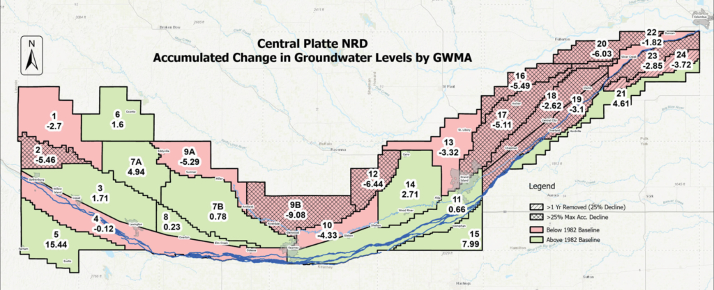
Groundwater Levels Remain Stable Across Most of CPNRD
Spring groundwater measurements showed a district-wide average decline of 0.42 feet from 2025 and 1.22 foot decline compared to the 1982 baseline year. CPNRD’s Groundwater Management Plan establishes maximum acceptable groundwater level declines and safety margins for each of the district’s 26 Groundwater Management Areas (GMAs). Based on the 2026 measurements, two GMAs have moved into Phase II management after reaching the 25% decline threshold: GMA 2 in Dawson County and GMA 18 in Merrick County. Phase II management includes restrictions on groundwater transfers and the development of supplemental irrigation wells.
Three areas that continue to experience groundwater declines and will be closely monitored include:
- GMA 9B (Buffalo County): Declined 0.16 feet from 2025 | 9.08 feet below the 1982 baseline
- GMA 16 (Merrick County): Declined 0.30 feet from 2025 | 5.49 feet below the 1982 baseline
- GMA 20 (Nance, Merrick, Platte counties): Declined 0.47 feet from 2025 | 6.03 feet below the 1982 baseline
The NRD’s Static Water Level Monitoring Network consists of 451 wells across the district, including 386 irrigation wells and 65 dedicated monitoring wells. These wells are measured each spring and fall as part of the district’s Groundwater Management Plan. Spring measurements are used to assess long-term groundwater level trends, while fall measurements help staff evaluate annual drawdowns and monitor short-term changes.
Since 2000, an average of 405 wells has been measured annually, equating to approximately one monitoring well for every 2,500 irrigated acres within the district. For the 2026 assessment, CPNRD staff collected measurements from 410 wells, consistent with the long-term average. This monitoring network provides critical data for tracking groundwater level trends and supports informed management decisions to help ensure the long-term sustainability of groundwater resources in central Nebraska.
Your CPNRD Contact: Luke Zakrzewski | luke@cpnrd.org | 308-395-7672
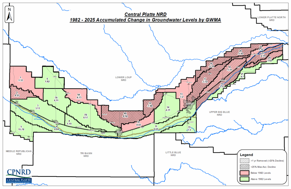
Spring 1982 - Spring 2025
The spring 2025 static groundwater levels showed a loss of only -0.80 feet District-wide compared to the levels in 1982. The 1982 levels were established as the baseline for the NRD’s Groundwater Management Plan, which includes maximum acceptable declines and a margin of safety calculated for each of the Groundwater Management Areas (GWAs). Since 1982, changes in the NRD’s 26 Groundwater Management Areas (GMAs) range from an increase of 15.78 feet in GMA 5 (Frontier and Buffalo counties), to a decrease of -9.92 feet in GMA 9B (Buffalo County). CPNRD staff reads over 400 wells each spring to monitor groundwater levels. For the 2025 assessment, 416 wells were measured, which equates to one well per 2,500 irrigated acres.
Fall 2023 - Fall 2024
409 wells measured between spring and fall 2024, 244 wells recorded an average decline of 2.41 feet, while 165 wells showed an average increase of 1.27 feet. Note: it is typical for groundwater levels to drop during the fall due to the annual drawdown from the irrigation season. The yearly comparison of groundwater levels from fall 2023 to fall 2024 showed that 119 wells experienced an average decline of 1.13 feet, while 276 wells recorded an average increase of 1.72'. Groundwater Management Areas 9A (northern Buffalo County) and 13 (parts of Hall, Howard, and Merrick counties) continued to show declining levels. He said these areas could soon reach their maximum acceptable decline triggers. As part of the CPNRD Groundwater Management Program, staff measures water levels in irrigation observation wells and dedicated monitoring wells annually, during the spring and fall. On average, 405 wells have been assessed annually since 2000. Fall readings are not used in groundwater management decisions.
Fall 2023 Report
Of the 386 wells read from spring 2023 to fall 2023, 311 declined an average of 2.80 feet. Precipitation in the western area of the district aided in increases in 55 wells at an average of 3.44 feet. A fall-to-fall comparison of 377 wells read from 2022 to 2023 showed that 263 wells had declines averaging 1.52 feet. 114 wells increased an average of 1.48 feet. Fall readings are not used in groundwater management decisions.
Spring 1982 – Spring 2023
The spring 2023 static groundwater levels showed declines in all 24 GWMAs within CPNRD compared to the groundwater levels in 1982. There were 376 wells, 4 wells per township, were included in the assessment. The entire District had an accumulated loss of -1.30 feet and -0.80 feet since 1982. Four of the GWMAs (2, 16, 17, 18) triggered below 25% decline. Three GWMAs continue to show declines and are under additional management restrictions :
- GWMA 9 is down 1.18 ft. from the previous year (-9.06 ft. to -10.24 ft)
- GWMA 16 is down 3.26 ft. from previous year (-2.17 ft. to -5.43 ft.)
- GWMA 20 down 2.15 ft. from previous year (-4.78 ft. to -6.93 ft.).
Subdivision Reassessment
The boundaries for Sub-Areas 7a, 7b, 9a, and 9b were reassessed in August 2023 for the CPNRD’s Groundwater Management Program. The Board subdivided Groundwater Management Areas 7 and 9 in the updated Groundwater Management Plan due to differences in irrigation development that have occurred in the two areas and to address groundwater levels in parts of those GWMAs that have some decline concerns. The original management plan and boundaries were developed using surface topography, soils, aquifer-saturated thickness, and government boundaries (section lines, county boundaries, etc.). 2,853 wells, including 113,000 readings for static water levels, were used to reassess the new sub-areas.
in May 2023, the Board approved updates to both the water quantity and water quality portions of the Plan; which became effective on July 1, 2023.
Changes to the water quantity section include:
Phase I - Trigger changed to a range of 0-25% of the Maximum Acceptable Decline (MAD).
Phase II - Applies to any area with declines greater than 25% of the MAD.
Phase III - Changed to 50% decline in water levels relative to the MADs.
Phase IV - If water levels in a given GWMA continued to decline and reached 75% of the MAD.
Phase V - Implemented if Phase IV MAD is 100% reached or exceeded.
The preferred option for groundwater quantity management controls related to each phase is measuring devices and a limit on the volume of groundwater pumped.
Phase I - No additional management requirements.
Phase II - Remains as is with limitations on transfers and supplemental wells.
Phase III - When trigger is reached, measurement devices required on all active irrigation wells in the GWMA, and the owner/operator of every active well required to report annual water usage to the NRD.
Phase IV - When trigger is reached, CPNRD will allocate groundwater use to prevent the GWMA from reaching the MAD.
Phase V - If initial allocation is insufficient to prevent reaching the MAD, and that MAD is reached/exceeded, it would require a reduction of the allocation.
Your Contact
Luke Zakrzewski, GIS Image Analyst
-
Main Office
- 215 Kaufman Ave, Grand Island, NE 68803 308-385-6282
-
Cozad Office
- 75887 Road 414, Cozad, NE 69130 308-380-8943
-
NRCS Field Offices (Ext. 3)
- Central City 308-946-3035
- Kearney 308-237-3118
- Grand Island 308-395-8586
- Lexington 308-324-6314
- Osceola 402-747-2111
-
Quick Links
© 2026 Central Platte Natural Resources District