Recharge Canals

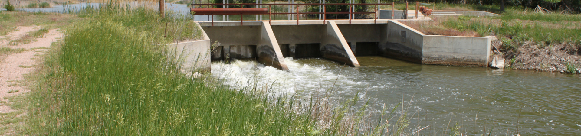
Putting Water Back to the Platte River

The NRD has been proactive in creating new ways to increase irrigation efficiency, protect water supplies, and increase flows to the Platte River by working with the canal companies in Dawson County. The Canal Rehabilitation Project was initiated to:

  • Help meet requirements of the Platte River Recovery Program agreement between Colorado, Wyoming, Nebraska, and the U.S. Department of Interior.
  • Help meet the requirements of LB 962 to return the Platte River to 1997 level of use and return the area between Lake McConaughy and Elm Creek from an over-appropriated to a fully appropriated condition.
  • Protect the agricultural economy by allowing all existing irrigated land to stay in production as irrigated land.
  • Increase flows to the Platte River protecting water supplies, municipal well fields, future water users and endangered species, by increasing flows to the river.
  • Provide groundwater recharge that protects water supplies for surface water and groundwater users and protects water quality.
  • Protect all existing water rights.

Over-Appropriated Area Retirements
By the close of 2020, the CPNRD Water Bank had a balance of 2,122 acre-feet of groundwater rights available for offset in the across the district and 2,500 ac-feet of surface water rights available for offset in the over-appropriated area.

Excess Flows
Excess Platte River flows were diverted by Cozad Canal, Thirty Mile Canal, and South Side Irrigation canals in 2011, 2013, 2014, 2015, 2016, 2017, 2018, 2019.  Total diverted by the three canals was 89,590 AF and the computed recharge was 40,512 AF.  In 2020, 2,950 AF (net diversion) of water was diverted for recharge through the canals.


Video

Irrigation Canal Locations
Cozad Canal: 75885 Road 414, Cozad, NE
Thirty Mile Irrigation District: 75885 Road 414, Cozad, NE
Southside/Orchard Alfalfa Canal: 42030 Road 759, Cozad, NE

Six-Mile Canal

This canal was the first canal that the NRD partnered with and the only canal that the NRD purchased with the intent to close it. After 116 years of use, landowners and farmers along the canal were eager to convert their land to groundwater use; which is more efficient and reliable than surface water. It also helps protect river flows and endangered species. The canal had been in place and diverting Platte River water since 1894, withdrawing an average of 2,377 acre-feet of water annually.

Fact Sheet

Cozad Ditch Company

The NRD partnered with Cozad Ditch Company in 2012 to manage the canal and to lease surface water as part of its efforts to increase Platte River flows and protect endangered species. The increased flow levels are required under the Platte River Recovery Implementation Program (PRRIP) and state law. Unused surface water flows are diverted from the irrigation canal back into the Platte River. The NRD also utilizes the canal after irrigation season to recharge excess Platte River flows when available.

By diverting the excess flows into the canal, water will recharge the aquifer and will filter back into the Platte River. The NRD helped fund a complete rehab of the canal to create a more efficient system. The canal has been in place diverting Platte River water since its water right was approved in 1894; with water rights to irrigate over 25,000 acres of land in the area between Gothenburg and Lexington in Dawson County. Grants from the Platte Basin Habitat Enhancement Program; which involves money from Platte Basin NRDs, the Nebraska Environmental Trust, and the state water management fund; paid for 60% of project costs.

Fact Sheet

Thirty-Mile Irrigation District

The CPNRD-Thirty Mile Canal Company purchase agreement is different in that the NRD purchased ownership in the amount of $2 million for half interest in the irrigation system. This includes 50% of Thirty Mile Irrigation District’s water rights and 50% of the value of buildings and equipment. The partners use the canals after irrigation season to hold diverted off-season excess Platte River flows when available.

Water seeps from the canals into groundwater that is hydrologically connected to the river and provides river enhancement credits. Grants from the Platte Basin Habitat Enhancement Program; which involves money from Platte Basin NRDs, the Nebraska Environmental Trust, and the state water management fund; paid for 60% of the project costs or $1.8 million. Thirty Mile project was constructed in 1927 and now has 52 structures including bridges, siphons, and culverts that will be replaced in the later phases. Photo to left: Mike Ostergard and Jim Harris, Canal Manager..

Fact Sheet

Southside Irrigation District

The NRD and Southside Irrigation District have a management-lease agreement for the Orchard/Alfalfa Canal. As part of the agreement, the CPNRD assists in operations for all of the irrigation district’s benefits and is responsible for half of the operations and maintenance costs. The NRD uses the canal after irrigation season to hold diverted off-season excess Platte River flows when available.

Water seeps from the canals into groundwater that is hydrologically connected to the river and provide river enhancement credits for Southside and the NRD. The project was funded through the Nebraska Department of Natural Resources Water Cash Fund at 60%, Southside Irrigation Company at 20% and Central Platte NRD at 20%.

Fact Sheet

The canal rehabs were developed as result of the NRD’s Water Banking Program; which began in January 2007 to try to reduce the need to regulate irrigators within the District. As part of the program, the NRD purchases water rights as a solution to balance water that is being used with water that is available. Two major programs required the NRD to find a solution– the Platte River Recovery Implementation Program (PRRIP) and Legislative Bill 962 (LB962).

The NRD must stay in compliance with both of these programs. Currently, the majority of the NRD is at its limit for water use, known as fully appropriated. The westernmost part of the District, above Elm Creek, is designated as over-appropriated; which requires the NRD to bring water back to a fully appropriated status.  The Water Bank holds permanent easements on land accepted into the program and pays landowners to convert the irrigated land into dry land.

Central Platte NRD’s water bank was the first to be implemented in Nebraska. At least three other Natural Resource Districts (NRDs) currently considering water banks in the Platte Basin, especially those that have been declared over-appropriated. These NRDs include the Twin Platte NRD in North Platte, the Tri-Basin NRD in Holdrege and the North Platte NRD in Gering.

In January 2007, the board of directors approved the first water bank transaction in the district by approving a variance request and the deposit of 2.4 acre-feet per year into the District’s water bank. Jim Bendfeldt made the donation of the offset water. The CPNRD Water Banking Policy was implemented in May 2007, which defines the process of a how the water bank works. Through the water bank program, the NRD acquires water rights from landowners. For every acre-foot of water that impacts the river that the NRD can acquire, there’s that much less regulation and cutback the NRD will have to impose