News

Groundwater Levels Remain Stable Across Most of CPNRD
June 16, 2026
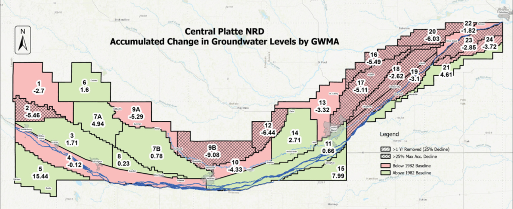
Spring groundwater measurements showed a district-wide average decline of 0.42 feet from 2025 and 1.22 foot decline compared to the 1982 baseline year. CPNRD’s Groundwater Management Plan establishes maximum acceptable groundwater level declines and safety margins for each of the district’s 26 Groundwater Management Areas (GMAs). Based on the 2026 measurements, two GMAs have moved into Phase II management after reaching the 25% decline threshold: GMA 2 in Dawson County and GMA 18 in Merrick County. Phase II management includes restrictions on groundwater transfers and the development of supplemental irrigation wells.
Three areas that continue to experience groundwater declines and will be closely monitored include:
- GMA 9B (Buffalo County): Declined 0.16 feet from 2025 | 9.08 feet below the 1982 baseline
- GMA 16 (Merrick County): Declined 0.30 feet from 2025 | 5.49 feet below the 1982 baseline
- GMA 20 (Nance, Merrick, Platte counties): Declined 0.47 feet from 2025 | 6.03 feet below the 1982 baseline
The NRD’s Static Water Level Monitoring Network consists of 451 wells across the district, including 386 irrigation wells and 65 dedicated monitoring wells. These wells are measured each spring and fall as part of the district’s Groundwater Management Plan. Spring measurements are used to assess long-term groundwater level trends, while fall measurements help staff evaluate annual drawdowns and monitor short-term changes.
Since 2000, an average of 405 wells has been measured annually, equating to approximately one monitoring well for every 2,500 irrigated acres within the district. For the 2026 assessment, CPNRD staff collected measurements from 410 wells, consistent with the long-term average. This monitoring network provides critical data for tracking groundwater level trends and supports informed management decisions to help ensure the long-term sustainability of groundwater resources in central Nebraska.
Your CPNRD Contact: Luke Zakrzewski | luke@cpnrd.org | 308-395-7672
-
Main Office
- 215 Kaufman Ave, Grand Island, NE 68803 308-385-6282
-
Cozad Office
- 75887 Road 414, Cozad, NE 69130 308-380-8943
-
NRCS Field Offices (Ext. 3)
- Central City 308-946-3035
- Kearney 308-237-3118
- Grand Island 308-395-8586
- Lexington 308-324-6314
- Osceola 402-747-2111
-
Quick Links
© 2026 Central Platte Natural Resources District